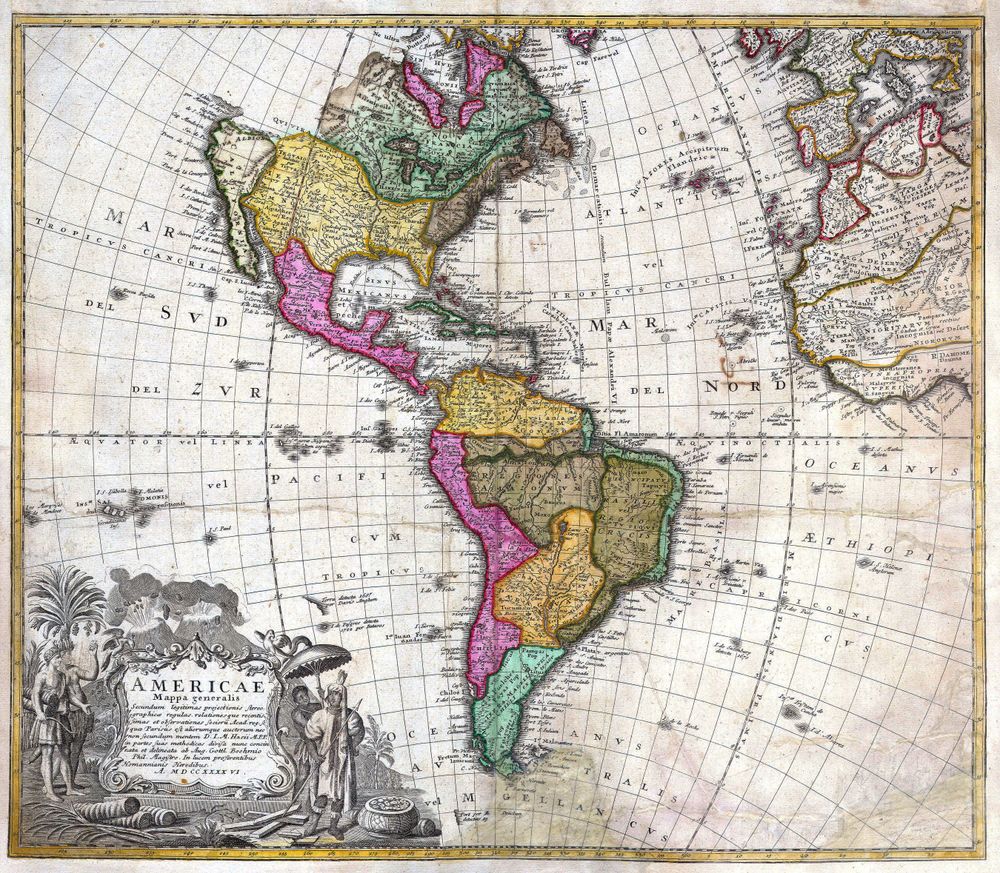
Antique Map America 1746 Homann Heirs Map of South North America Geographicus Americae Hmhr 1746
Buy this print on Etsy →Two great continents unfurl across a single sheet in this 1746 map of the Americas, drawn when North and South America were still half-charted mysteries to European eyes. The Homann Heirs workshop of Nuremberg engraved a sweeping view that runs from the frozen edges of the north, down through the Gulf and the Caribbean islands, to the tapering cone of Patagonia and the storm-worn passage of Cape Horn. Coastlines are firm and confident where mariners had sailed, and softer, more speculative inland, where the interior was still the domain of rumor and report.
This is copperplate engraving at its mid-eighteenth-century height. Every river, mountain range, and provincial boundary was cut by hand into a polished plate, the fine hatching giving depth to oceans and terrain alike. A decorative cartouche frames the title in the ornamented Baroque manner of the German mapmaking houses, and period hand coloring picks out empires and coastlines in soft washes of rose, ochre, and sea green. It is a document of an age when a printed map was both a scientific instrument and a work of art, a way of holding the whole New World in your hands.
Our reproduction honors that heritage with modern archival craft. Each print is produced on museum-grade 189gsm archival matte paper using pigment inks, so the antique linework stays crisp and the aged tones stay true, resistant to fading for generations. The matte surface has a natural, paper-forward finish with no glare, letting every engraved detail read clearly. Please note this is a fine-art reproduction created for display, not an original antique map.
Choose from five sizes to suit your wall: 8x12, 12x18, 16x24, 20x30, and 24x36 inches. Prints ship rolled in a protective tube and arrive ready to frame, so you can mount them in the frame and mat of your choosing.
An antique map print of the Americas brings quiet gravity to a study, a home office, or a personal library, the kind of piece that rewards a second look. It suits the collector of vintage cartography, the traveler with a restless imagination, and anyone drawn to old world map wall art with real history behind it. Hang it above a desk as a daily invitation to wander, anchor a reading nook, or build a gallery wall of historical map posters exploring continents and centuries. Larger sizes make a commanding statement over a sofa or console; smaller ones slip neatly into a bookshelf vignette. It also makes a thoughtful gift for the history lover, the geography enthusiast, or the friend who is forever planning the next journey.
More than decoration, this old map print carries the wonder of eighteenth-century discovery into a contemporary room, a reminder of how boldly earlier generations tried to draw a world they were still learning to know. Bring home the romance of early cartography and let the Americas of 1746 spread across your wall.