The Floor of the Oceans Map Poster 1976
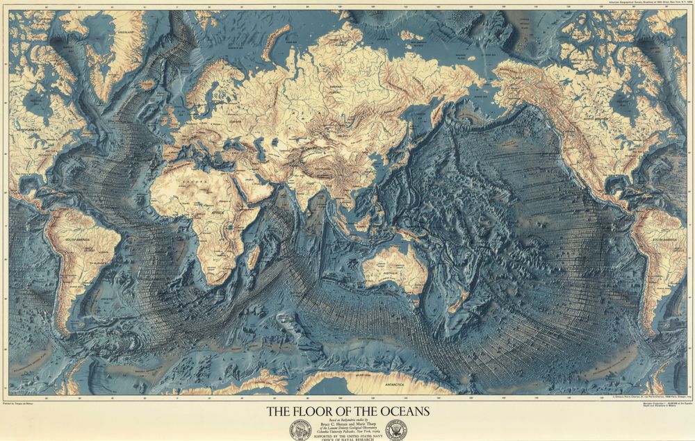
Buy this print on Etsy →"The Floor of the Oceans" is one of the most beautiful and important scientific maps of the twentieth century — a sweeping panoramic portrait of the world's seabed with the water stripped away, revealing the mountains, trenches, ridges, and plains hidden beneath the waves. Rendered in luminous blues and warm tans, the map turns cold bathymetric data into a work of art, letting the eye travel along the great mid-ocean ridges and down into the deepest trenches as though flying low over a drained planet.
Behind the beauty lies a landmark of earth science. The map grew out of decades of painstaking work by two researchers at Columbia University's Lamont Geological Observatory: the geologist Bruce Heezen and the geologist and oceanographic cartographer Marie Tharp. Working from sounding data gathered by research ships crisscrossing the oceans, Tharp plotted the profiles of the seafloor and, in doing so, identified a continuous rift valley running down the center of the Mid-Atlantic Ridge. That discovery provided crucial visual evidence for seafloor spreading and plate tectonics, helping to overturn old ideas and transform our understanding of how continents move and how the Earth itself works.
To turn their scientific diagrams into a panorama that anyone could grasp, Heezen and Tharp collaborated with the Austrian landscape painter Heinrich Berann, celebrated for his sweeping panoramic maps of the Alps and national parks. Berann's artistry gave the seafloor its dramatic, almost sculptural relief — the sense that you are gazing at real terrain, lit from the side, with every ridge and abyss casting its own shadow. The result is a map that reads equally as science and as landscape painting.
This reproduction is a vivid, high-quality print of that iconic panorama, faithful to the rich colour and intricate detail of the original. It is produced on premium archival matte paper with true-to-life colour and crisp definition, so the fine texture of the ridges and basins stays sharp.
A striking centerpiece for a study, office, library, classroom, or living room, "The Floor of the Oceans" appeals to lovers of maps and cartography, students and teachers of geology and oceanography, sailors and divers, and anyone fascinated by the hidden landscape beneath the sea. It pairs beautifully with other vintage maps, nautical charts, and science prints, and makes a thoughtful, intelligent gift for the scientifically curious.
More than decoration, this map is a piece of intellectual history — the image that helped a generation finally see the shape of the ocean floor and understand the restless machinery of our planet. Displayed on a wall, it is both a handsome object and a quiet invitation to wonder at how much of our own world lay unseen until remarkably recently, and at the patient, ingenious work that finally brought it into view for everyone to explore.
First issued in the 1970s, when the Heezen-Tharp-Berann panoramas reached a wide public audience, "The Floor of the Oceans" has never lost its power to fascinate. Marie Tharp, long under-credited for her role, is now recognised as one of the pioneering figures of modern oceanography, and the map endures as a tribute to her vision — a rare object that is at once a rigorous scientific document, a milestone in the story of plate tectonics, and a genuinely gorgeous piece of art for the wall.